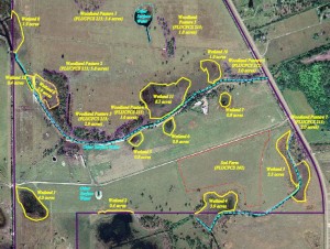
This map is the result of many hours of field investigations by a soil scientist and biologist determining the breaks between hydric soils and wetland vegetation and upland soils and vegetation.
Wetland conservation is aimed at protecting and preserving areas where water exists at or near the Earth’s surface, such as swamps, marshes and bogs. Wetlands cover at least six per cent of the Earth and have become a focal issue for conservation due to the ecosystem services they provide.
Various definitions of wetlands exist. The Convention on Wetlands of International Importance, also known as the Ramsar Convention, defines wetlands as including: lakes and rivers, swamps and marshes, wet grasslands and peatlands, oases, estuaries, deltas and tidal flats, near-shore marine areas, mangroves and coral reefs, and human-made sites such as fish ponds, rice paddies, reservoirs, and salt pans. Meanwhile, the United States Environmental Protection Agency (EPA) or Wetlands Reserve Program, describes wetlands as “those areas that are inundated or saturated by surface or groundwater at a frequency and duration sufficient to support, and that under normal circumstances do support, a prevalence of vegetation typically adapted for life in saturated soil conditions. Wetlands generally include swamps, marshes, bogs and similar areas.” Wetlands vary widely in their salinity levels, climatic zones, supported flora, surrounding geography, whether they are coastal or inland and so on.

