According to the Federal Register, July 13, 1994: “A hydric soil is a soil that formed under conditions of saturation, flooding, or ponding long enough during the growing season to develop anaerobic conditions in the upper part.”
Florida Hydric Soil Indicators for Delineation
These indicators are to be used for all soils regardless of texture.
A5. Stratified Layers. For use in all Land Resource Regions (LRR’s). Several stratified layers starting within the upper 6 inches of the soil surface. One or more of the layers has value 3 or less with chroma 1 or less and/or it is muck, mucky peat, peat, or mucky modified mineral texture. The remaining layers have value 4 or more and chroma 2 or less.
A6. Organic Bodies. For use in all LRR’s. Presence of 2% or more organic bodies of muck or a mucky modified mineral texture, approximately 1 to 3 cm in diameter, starting within 6 inches of the soil surface.
A7. 5 cm Mucky Mineral. For use in all LRR’s. A mucky modified mineral surface layer 2 inches or more thick starting within 6 inches of the soil surface.
A8. Muck Presence. For use in LRR U. A layer of muck 1 cm or more thick with value 3 or less and chroma 1 or less starting within 6 inches of the soil surface.
A9. 1 cm Muck. For use in LRR’s P and T. A layer of muck 1 cm or more thick with value 3 or less and chroma 1 or less starting within 6 inches of the soil surface.
Hydric Soil Delineation Indicators for Sandy Soils These indicators are to be used for soil materials with a USDA texture of loamy fine sand and coarser.
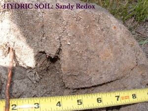
S5. Sandy Redox. For use in all LRR’s. A layer starting within 6 inches of the soil surface that is at least 4 inches thick, and has a matrix with 60% or more of its volume chroma 2 or less with 2% or more distinct or prominent redox concentration as soft masses and/or pore linings.
S6. Stripped Matrix. For use in all LRR’s. A layer starting within 6 inches of the soil surface in which iron/manganese oxides and/or organic matter have been stripped from the matrix exposing the primary base color of soil materials. The stripped areas and translocated
oxides and/or organic matter form a diffuse splotchy pattern of two or more
colors. The stripped zones are 10% or more of the volume; they are rounded and
approximately 1 to 3 cm in diameter.
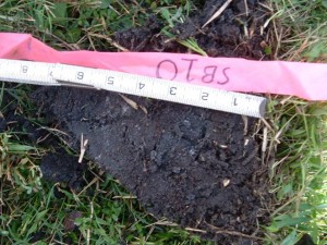
S7. Dark Surface. For use in all LRR’s. A layer 4 inches or more thick starting within the upper 6 inches of the soil surface with a matrix value 3 or less and chroma 1 or less. At least 70% of the visible soil particles must be covered, coated, or similarly masked with organic material. The matrix dark layer must have chroma 2 or less.
Hydric Soil Delineation Indicators for Loamy and Clayey Soils These indicators are to be used for soil materials with a USDA texture of loamy very fine sand and finer.
F3. Depleted Matrix. For use in all LRR’s. A layer with a depleted matrix that has 60% or more chroma 2 or less that has a minimum thickness of either:
- 5 cm (2 in.) if 5 cm (2in.) is entirely within he upper 15 cm (6in.) of the soil, or
- 15 cm (6in.) and starts within 25 cm(10 in.) of the soil surface.
A and E horizons must have common to many, distinct or prominent redox concentrations. The following combinations of value and chroma identify a depleted matrix:
1. Matrix value 5 or more and chroma 1 with or without redox concentrations; or
2. Matrix value 6 or more and chroma 1 with or without redox concentrations; or
3. Matrix value 4 or 5 and chroma 2 and 2 percent or more distinct or prominent redox concentrations; or
4. Matrix value 4 and chroma 1 and 2 percent or more distinct or prominent redox concentrations.
F6. Redox Dark Surface. For use in all LRR’s. A layer at least 4 inches thick entirely within the upper 12 inches of the mineral soil that has:
- Matrix value 3 or less and chroma 1 or less and 2% or more distinct or prominent redox concentrations as soft masses or pore linings, or
- Matrix value 3 or less and chroma 2 or less and 5% or more distinct or prominent redox concentrations as soft masses or pore linings.
F8. Redox Depressions. For use in all LRR’s. In closed depressions subject to ponding, 5% or more distinct or prominent redox concentrations as soft masses or more thick entirely within the upper 6 inches or more thick entirely within the upper 6 inches of the soil surface.
Redox Depressions User notes: This indicator occurs on landforms such as: “Grady” ponds, and potholes: not micro-depressions on convex or plane landscapes.
F10. Marl. For use in LRR U. A layer of marl with a value 5 or more starting within 4 inches of the soil surface.
Normally this indicator occurs at the soil surface.
F12. Iron/Manganese Masses. For use in LRR’s P and T. On flood plains, a layer 4 inches or more thick with a depleted matrix that has 40% or more chroma 2 or less, and 2% or more distinct or prominent redox concentrations as soft iron/manganese masses with diffuse boundaries. The layer occurs entirely within 12 inches of the soil surface. Iron/manganese masses have value 3 or less and chroma3 or less; most commonly they are black. Iron/manganese masses are usually small (2 to 5 mm in size) and have a value and chroma 3 or less. This indicator occurs on flood plains of rivers such as the Apalachicola.
F13. Umbric Surface. For use in all LRR’s. In depressions and other concave positions, a layer 6 inches or more thick starting within the upper 6 inches of the soil surface with value 3 or less and chroma 1 or less immediately underlain by a layer 4 inches or more thick with chroma 2 or less.
These indicators were developed by G. Wade Hurt, University of Florida.


